
WE GO MAPPING SO YOU CAN GO FISHING
FishTec charts are high-definition fishing charts tailored for fishfinders, delivering detailed insights into a lake’s underwater structure and features. Available in multiple formats – contour charts, sediment charts, and satellite imagery – these charts help anglers pinpoint fish-holding spots and boost their fishing success.
Types of Charts
Contour Charts:
These charts reveal a lake’s fundamental underwater structure, highlighting contours, humps, and drop-offs. FishTec employs contour intervals of 1ft in shallow areas and 3ft in deeper zones for precise navigation.
Sediment Charts:
Crafted from data sourced from the Department of Water Affairs, these charts detail underwater features such as old roads, bridges, foundations, and other points of interest, helping anglers navigate and target key fishing spots.
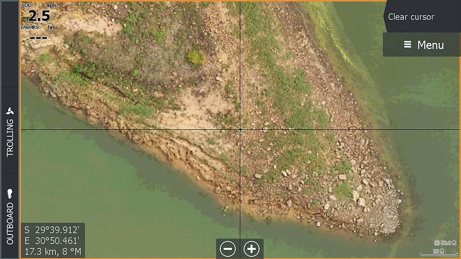
Satellite Charts:
Utilizing satellite imagery, these charts deliver a high-resolution view of a lake’s surface and shoreline, showcasing details such as vegetation, rocks, and other notable features.
Additional Features:
FishTec charts may also offer features such as UltraHF mosaic, AerialHD, and bottom hardness data, improving anglers’ ability to visualize and interpret the lake’s environment effectively.
Benefits of FishTec Charts
Enhanced Fish Finding:
By mapping underwater structures and features, anglers can more effectively locate potential fish-holding spots, boosting their chances of a successful catch.
Increased Accuracy:
Detailed contour and sediment data enable anglers to cast with greater precision and navigate lakes more confidently.
Strategic Fishing Advantage:
FishTec charts provide insight into a lake’s topography, empowering anglers to create more effective and strategic fishing plans.
Who Uses FishTec Charts?
FishTec charts are a go-to tool for anglers like me aiming to boost fishing success and better understand a lake’s underwater environment. They’re especially favored by those fishing in large lakes and reservoirs, where navigation and locating fish-holding spots can be tricky.
COMPATIBILITY NOTE: FishTec charts don’t work with all fishfinders. Be sure to check compatibility with your device before purchasing—reach out to FishTec to confirm.
With FishTec HD Fishing Charts, this data is readily available directly on your fishfinder, eliminating the need to sift through countless photos. You can zoom in and scroll around the images to spot critical objects that fish might be drawn to, making your fishing more effective.
To get your Fishtec HD Fishing Charts or get additional information you can contact Fishtec South Africa on one of the below mediums.
Alternatively visit Fishtec HD Fishing Charts website and check the offering they have on hand or reach out to the team for more information